Wednesday, February 29, 2012


 Standing by the minas de sufre, "the sulfur mines"- natural deposits of suflur in the caldera of Sierra Negra volcano, on Isabela
the small harbor of Isabela, taken from the lone pier

Time for adventures on San Cristobal, where I’ll spend most of the rest of the semester, until I return to the mainland for my research with tarantulas.  On Sunday, us kids in mountain geology left Isabella by boat and headed over open water for San Cristobal, by way of Floreana.   Water unt the small harbor of Isabela was low, so our water taxi had to take its time skirting around the shallows of the bay.  The lone pier is in water too shallow for anything but small boats to traverse, so larger boats stay further out in the bay, in the deeper section away from the white sand  and beside the black volcanic rock.  The Island of Floreana itself is large- we could see its multiple mountains clearly on the horizon- but the small, lone town is tiny.  I heard a range of population sizes from 89-100 people, but either way, almost none.  After a brief boat ride on what appeared to be one of only 2 water taxis on the island, we walked past the sea lions on the pier and up the dirt road pointed towards the highlands.  It was kind of like the islander version of a Western- a group of travelers from out of town walking up the single road in town.  We stopped and ate in, as far as we could tell, the only restaurant in town, munching on beans, rice, and fish under a palm leaf awning.  Afterwards, made a quick dip in a small bay in front of town-  Because it was on open water, it was pretty choppy, but the sea turtle and big trigger fish were a great surprise before we loaded back onto the boat.  

When we arrived at San Cristobal, seeing it emerge from the horizon, the town was bigger than I expected. Checking the place out before the trip with Google Earth, the satellite images made it seem incredibly small, and while Puerto Baquereza is my no means a metropolis, it’s 7000 inhabitants have a decently sized town.  The front of the town is bordered by the harbor, with dozens of boats of various sizes, from big tourist boats the furthest out to little water taxis all spread out from its three piers.  These piers branch off of the malecon, the board walk that runs the length of the harbor, with the town beginning behind it.  Most of the shops on the malecon are either restaurants, dive shops, or souvenir shops for tourists, with 2 main blocks further back before the town starts to spread out a bit.  From town, we all boarded a bus for the short ride to the GAIAS building, on the northern edge of the bay.  Situated across the street from the playa Mann, it has as perfect view of the harbor to the front, and land of the Parque Nacional de los Galapagos behind it.  A brief introduction and tour of the building led us to the few class rooms, library, and lounge upstairs, before we went out to meet our host families.  In front of the building, my host brother Ivan was waiting for me.  23, he’s grown up on the Island, but has spent time travelling on the mainland with his band.  The youngest of 5, he’s currently the only one on the Island, and staying with my host mum, Sonia.  Right now, the two are in the middle of moving to house near the university, so we’re staying in my host sister (who’s on the mainlands)’s apartment, in the center of town. 
 shot from the malecon of the habor at low tide, with one of the occasion freightors in port

Sonia has a cool little restaurant, Café del Mar, on the Malecon, overlooking the harbor, and surrounded by sea lions.  The sea lions at San Cristobal are kind of like cats- they lay all over the Malecon, expecting everyone to go around them and lazing (seemingly) without care.  Not exactly true for the big males though, who each guard a harem of females and have to defend, as one guy told me in broken English, “their womens.”

This weekend was spent exploring around town, and trying to get to know it well enough to keep up with the non-mountain geology kids, who have already been here for a week.  Sunday was my introduction to Playa Corolla, a little ways from GAIAS, but still an easy walk.  There, after swimming for a while, we were joined by a baby sea lion, whose mother had gone into the water and left him on the beach.  Looking for his mum, he came right up to us, trying to figure out what we were, mewing the whole time.  Needless to say, he was pretty adorable, but alas, we couldn’t touch him for his own good, though I doubt he would have minded it.  The next day, right as I was about to leave corolla after a little snorkeling (with my phone in my pocket…) I saw fins flapping against the surface:  as I got closer, I realized in as a big ray (a spotted eagle ray), five feet across, breaking the surface with the ends of his fins.  It was only on closer inspection that I realized there was a second ray below him, and that the two were in the middle of mating.  Their distraction explained why they had drifted so close to sure- close enough that I could have jumped onto them without a running start.  They stayed close to shore for a couple minutes, before finally breaking apart and heading into deeper water.
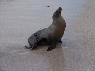
 A sea lion on the beach at playa Corolla

On Monday, I started my marine ecology class, taught by Luis and Max, a professor from USFQ and his german grad student, respectively.  Both are really nice, and were a great asset yesterday afternoon when the class when snorkeling at la Loberia, a small sheltered bay east of the town.  They helped to point out what we were looking at during out snorkeling- everything from a couple different types of sea urchins (pencil urchins & green urchins) to damsel fish, which garden a patch of their preferred algae on a rock, and chase away other herbivores while weeding out other species of algae from their patch.  We also spotted a big sea turtle, who, instead of swimming about, was sitting on the shallow bottom with his fins folded under him like a dog.  The loberia, as its name suggests, used to have a lot of sea lions (lobos marinos), but after the construction of the airport, the occasion take offs and landings of planes, directly over the loberia, drove them to prefer the malecon as a quieter abode. 


 A baby sea lion we befriend on the beach at San Cristobal

Wednesday, February 22, 2012

Waisting away in Margaritaville


Finally on the islands!  I really enjoyed my time on the mainland, and I’m going to miss it, but I am glad to have reached the Galapagos.  Early Sunday morning, we met at USFQ and then headed to Quito to our flight, which after a quick stop in Guayaquil, headed out over the Pacific for 761 miles.  The first island we saw was San Cristobal, the easternmost of the main 3, as we continued on to Santa Cruz, the most populous of the islands.  As we neared the airport on Baltra, the small island a few hundred meters north of Santa Cruz, we were low enough to get a good look at the sparce vegetation and red rock of the island.  As soon as we got off the plane, we were hit by the heat- that wasn’t as bad as I had expected, though the sun was intense, but all that was minor compared to the fact that I was on the Galapagos!  The quick ferry ride from Baltra to Santa Cruz was our first intro to how clear and sapphire the water of the islands was- I didn’t have to look hard to find fish among the blue water and black volcanic rocks.  On the other side of the channel, we bused the 37 km to Puerto Ayora, the main town of Santa Cruz, ate a quick lunch, and saw our first sea lions & finches before boarding a boat for the 2 hour crossing to Isabela.  The back of the boat where we rode was open air but mostly covered, so we had perfect views of Santa Cruz fading behind us as the twin-outboards kicked up a white rooster tail of spray over the dark blue water.  Half way over, we rushed through a wall of rain, the sky and water both turning to grey as we huddled out of the rain, but just as quickly, we were though, and had clear sailing all the way to Isabela.
Out hotel on Isabel is the Hostal Gran Tortuga- and on an island of only 3000 with the population all clustered within a mile of each other in Puerto Villamil, it’s hard to be far from the beach.  Monday morning class was spent at a farm inland from the coast, where they raised gaint tortoises and a plethora of tropical fruits- maracoya, papaya, lemons, bananas.  After class was spend in the water, snorkeling by Isabela’s tiny harbor in a sheltered lagoon.  There were tons of fish, and a couple big turtles, including one that didn’t mind me hanging out beside it for a while. Tuesday, we hiked on Sierra Negra, the closest of the six main volcanoes on Isabela to Villamil.  A shield volcano, the slope of the mountain is very low, and we only had to hike uphill from the parking lot for 30 minutes before we reached the edge of the caldera.  Over 30km across, it’s the second largest caldera in the world, and was pretty impressive- the third closest to us was covered in a fresh lava flow from the 2005 eruption, and below the surface the rock was still warm, though not molten, and previous night’s rain was evaporating from the caldera as rising curtains of steam.  It was an awesome sight; it wasn’t volcanic gas like we originally thought, but a great view none-the-less.  Hiking around for a portion of the rim, we eventually left the crater and head downhill to Volcan Chico, a series of cinder cones formed as satellites of the main volcano during an eruption in the 70s.  The landscape was completely barren, covered in dried lava flows and lava tunnels.  Despite the stereotype, it wasn’t all black- the lava flow ranged from reddish brown to black, and sulfur deposits left yellow and orange marks on a lot of the rock.  After scrambling to the top of one of the cones made of loose pumice, we returned to greener parks of Sierra Negra. 
Tuesday also marked the last day of Carnival on the island, though Monday was a much larger day of partying.  On the main beach in front of town, split by a pier built from volcanic rock, the town had set up a grounds for the ongoing festivities.  A stage for music and multiple tents set up for vendors and a DJ booth ring a central square of sand.  Music constantly came from the beach, either from musicians of speakers, starting in the morning as people conjugated there, and lasting til late in the night past my bedtime. Colored lights set up over a lot of the booths kicked in at night, and smells from the assorted grills and impromptu bars set up below the lights.
Today was another awesome day of snorkeling- after a test for geology.  The strictly academic part of the day out of the way, we took a cheva, the open air buses built on the backs of trucks, to the “harbor” and loaded into three small boats, then powered west out of town for 45 minutes before we began out approach to the lava tunnels we were to snorkel in.  Cutting through thick surf, we enter the calm of the protected maze of the tunnels.  Almost all of the tunnels had collapsed with age and water action, leaving just mounds of broken black lava, segments were plentiful, appearing as stone bridges over stretches of lagoon water. It was very primordial- the sparce tufts of grass and withered cactuses mounted on black arches over the clear blue water. Zig-zagging through the water, we went deep into the maze before stopping to walk on the bridges of piles of rock, then returned to the boats to enter the water.  Almost immediately, a curious sea lion, a lobo de marino, appeared to check us out, and didn’t mind us pooling around him as he scratched on rocks and pondered us.  The black protrusions from the bottom were a neat obstacle course to swim through, face down in the water.  After a while, we boated down the coast towards Puerto Villamil before returning to the water to a smaller, though no less impressive sheltered lagoon.  In the water, we didn’t see any more sea lions, but we encountered about everything else.  A couple big turtles were in the open by the boats, and plenty of small fish, as well as big parrot fish and an octopus inhabited the rocks.  Oh, and of course there were the sharks.  Multiple times as I rounded rocks, I ran into white-tip reef sharks, about 2 meters long and cruising near the bottom.  For all a shark’s reputation, they were the most skiddish wildlife on the reef, always swimming away from me, except when I trapped one against a rock face that breached the surface, and the shark had to dive below me, his snout, cat-fish whiskers and all, leading the way to freedom.
                 

Sunday, February 19, 2012

Photos from Cotopaxi

I've gotta get up early in the morning to head out to the Galapagos, so I'm short on time for writing.  On the islands I'll have the time to write more about this weekend's hike to Cotopaxi, the most icon mountain in Ecuador, with it's perfect volcanic cone and looming summit.  Until later, here's this:


Friday, February 17, 2012

Roaming Quito

Today marked my last full day in Quito/Cumbaya- tomorrow I leave for Cotopaxi, and when I return late saturday afternoon, I'll have 12 hours to finish packing and get ready to head out to the Galapagos for the next 2.5 months.  Needless to say, I wanted to get a last dose of Quito until I come back in a few months.  On the bus ride to the city, the air above Quito was full of clouds and fog, making me doubt my decision a little, but by the time I arrived in the city, the air was clear of fog.  The clouds were still there, but no as heavy as they had seemed.  My first goal was to head to the Parque Carolina.  My ability to navigate the city is pretty decent, thought the Parque wasn't right on the Ecovia busline, so I had to use a bit of estimation of when to get off and head west from Avenue 6 de Deciembre.  The park itself wasn't too hard to find, and I spend a while crossing across it's green lawn as a light drizzle fell.  I stopped at the only open street vender and got a small bowl of ceviche (fish cooked with the acidity of lemon juice instead of heat), before heading across the park to grab a proper lunch.

Afterwards, I headed across the park again back to the bus stop to head to the Plaza Foch, in the Mariscol district, to pick up a sleeping bag from a gear rental shop to use on Cotopaxi.  Getting to the plaza wasn't a problem, but even though I've been to the shop before, refinding it took a bit of effort.  Afterwards, I swung by the Quito artisan market to track down a pair of the infamous "gringo pants."  I have no idea what they're actually called, but they look like pajamas, are insanely comfortable, and I have yet to see an Ecuadorian name them.  Tourist trap?  Maybe.  But I'm comfortable in my astoundingly comfortable, if heinously colored, lime and yellow pants.  Works for me!

Monday, February 13, 2012

Party Rock is in the mount tonight

Iliniza Norte

After the first week of my geology course, we headed out to the field in Banos, a city nestled by mountains south of Quito and known for its outdoor activities- rafting, zip lines, all that good stuff.  Alas, as it was a field trip, we didn’t get a chance to do all that.  On Friday, after the 3 hour ride down from Cumbaya, we stopped at out hotel to drop off luggage and grab lunch.  From there, we loaded back into the bus, and drove an hour down a narrow rode from the Inter-andean valley, over the Real Cordillera, the eastern half of the Andes, and to the edge of the Amazonian basis, following the Rio Pastaza through its steep canyons- a lot of times, we had to take tunnels through the middle of mountains rather than skirt their steep flanks.  The views were incredible, and waterfalls abounded.  We stopped outside of the town of Meras on a cliff overlooking the floodplain of the suddenly wider river, then turned around for the stop ridden trek back to Banos. Each of our stops was primed to put us in a different litho-techtonic unit, geologically distinct segments of the Andes separated by faults.  Along the stops, we got to check out different levels of metamorphism in the rocks, studying how they were affected by the forces that formed the Andes and changed from igneous to metamorphic rock.  While it was interesting, it dashed my previous assumptions that the three main types of rock were hard, classic, and party.  Sigh.   At our last stop, almost back to Banos, we saw where the river formed a massive waterfall and cut into a thick lava flow laid down by Tungurahua Volcano, which is still very active and overlooks the city, 2300 years ago.  It was pretty impressive how well the landscape hid a flow that was only 100 FEET THICK.  You know, just a tad bit of lava.  That night after dinner, a group of us went out to the thermal bath on the edge of town.  The town has a massive canyon to the front, and steep mountain, basically a cliff, behind it, with the hotspring set at the base of a waterfall on the end of the cliff.  


The waterfalls outside of town- between the two, you can see the inverse V that marks the boundary from lava flow on top, and bedrock below

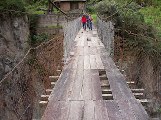
The next morning was spend looking at rocks in the canyon at the front of the town at the base of the big bridge crossing the river.  A narrow trail passed from the city level to the old, lower bridge, half way between the main bridge and the river.  And by lower bridge, I mean the rather sketchy and decrepit bridge.  But it can’t be that bad right- there were only a few missing panels.  As we walked down, Ben continued his usual teaching style in the field- forcing us to focus on our own observations.  We arrive at a rock face, and then spend a few minutes examining the rock individually, looking at the fractures in the surface and swinging the rock hammer to break off samples so we could see the inside of the rock, free of its external weathering.  When we reached the bottom bridge, we quickly crossed to get back on solid land, and got a look at the city side of the canyon, which had more exposed rock.  The view was impressive, and again we could see the clear line between the bottom bedrock and the thick lava flow above.  We also had a clear view of the city’s sewage being pumped into the river, dribbling out of a pipe high on the cliff face.  If we were in the US, such an impressive canyon would be a state park, or at least a municipal area and the sewage would be treated (probably), but this is Ecuador, and people have to live wherever they can, with what every they can.  It makes you realize why good health and low income tend not to live hand in hand.  
Figure A: How not to build a bridge


the first view of the Ilinizas- Sur on the left, Norte on the right

That afternoon, we drove back towards Quito, to the small hostal where we prepared for out ascent of Iliniza Norte.  The night was great was we were joined by not only the Esteban the Great, our tropical ecology professor, but his son, Juan, both there to summit the peak with us.  We crashed early after renting crampons and helments, to prepare for our alpine start.

At 430, we rose to the sound of rain, and ate breakfast hoping for it to end, which it quickly did.  Our bags loaded, we jumped in the backs of a convoy of pickups and made for the mountain.  At our first sight of the mountain, I realize that rain on the peak wasn’t what we had to worry about- except for exposed black rock, the whole 16,818 foot summit was white with snow.  Not only was it the tallest mountain I’ve been on, but by far the most intimidating.  From the end of the dirt road, below the snow line, we started out hike, stopping periodically to exam geologic features, like a thousand year old layer of ash from Cotopaxi.  As we mounted a snow-coated ridge to the summit, we saw Cotopaxi itself.  The most icon volcano in Ecuador, it’s perfect cone was coated in snow.  But who needs an idealized volcanic cone when I can have the jagged majesty of Iliniza?  At the top of the ridge was the refuge, a single room abode stocked with bunks and a single staff member.  I was rather surprised that you could buy hot foot so far up the mountain. But we had no time for that.  Joining Esteban & Juan, 5 of us began our bid for the summit.  Shortly after leaving the refuge, we put on our crampons, rather awkwardly, and feeling like pros, started up a steep snow slope towards the first summit-bound ridge.  I’m gonna be honest, at some points, I was rather sketched out, as we hiked up the steep slope by digging our crampons into the snow, sometimes clicking against the rock underneath, and came onto the ridgeline.  It felt like I was summiting Everest-  with clouds on both sides, crossing the narrow, snow covered ridge from rock outcrop to rock outcrop.  Being unable to see how far the sleep snow slopes fell away was very eerie, and I made sure I placed each step with care.
some jerk with Cotopaxi in the background
Estaban "the man" Suarez.  And Laura.
the recommended daily dose of huge scary mountain
Esteban admitted that he had never seen the mountain with this much snow, and after a particularly treacherous climb on a narrow band of snow around a tall, dark stone pillar, we stopped to consider it a summit attempt was still viable.  We were only 100 vertical meters below the summit, but that last section was nothing but vertical, ice covered rock.  In the epitome of irony, seconds after Esteban said we should turn around, we lost Juan and Kaitlin.  And by lost, I mean they lost they footing and slid into the fog down a boulder-strewn, 70 degree slope of snow that stretched for thousands of feet down the mountain.  Because they were side by side when they fell, they tumbled together, and Juan wasn’t able to stop his fall until he was almost lost in the clouds, driving his knees and elbows into the snow.  Kaitlin tumbled into the void, and we had a few moments of stunned silence before she finally called up that she was ok.  That stunned silence applied to all of us, except for Esteban.  When he saw what was happening, he, in true bad-ass fashion, flung himself down the slope after them.  He paused only to make sure his son was ok, then continued sliding down until he reached Kaitlin, helping her before she ran the risk of sliding again.  After that, it was pretty clear  that a summit attempt was out of the question, and we began the slow descent down the treacherous snow slope to meet up with the rest of our party.  We later learned that the other group turned back before the summit- though for not as cool a reason as us!


a plant